Research on Noto GIAHS and Biodiversity:アーカイブ
2024年11月18日
In preparation for COP29 held in Baku last year, the UNFCCC launched a podcast series called Climate Action 101. In the second episode, titled “Rio Conventions 101,” Researcher Koyama from UNU-IAS OUIK appeared alongside UNU-IAS Head of Programme and Administration Takemoto to discuss the history of the Rio Conventions (the three Rio Convetions) and the potential for youth to engage in addressing issues related to climate change and biodiversity.
Researcher Koyama also highlighted the importance of collaboration among various stakeholders—including the government, local communities, businesses, and youth—in the recovery efforts following the Noto Peninsula earthquake and torrential rain disasters that occurred last year.
To listen to the podcast, please click on the link below (available in English only):
Rio Conventions 101 Podcast.
2024年12月20日
The Second Meeting of the Noto GIAHS Biodiversity Working Group for FY2024 took place on the afternoon of Thursday, December 12, 2024, at Nanao City Hall.
Experts, local government officials, and representatives from related organizations attended the meeting, where they engaged in vibrant discussions about biodiversity monitoring activities and future strategies for the Noto region. A total of 27 participants were present, including those attending online.
To begin, the members shared updates on the current fiscal year’s status.
Despite the challenges posed by earthquakes and heavy rainfall, a total of 18 observation meetings were successfully conducted at 4 schools in Nanao City, 1 group in Shika Town, and 9 schools in Suzu City. Additionally, expert members reported on various research activities, including surveys of ibis feeding grounds, biological assessments in elevated areas, investigations of seafloor topography, and seaweed bed studies.
Participants highlighted the importance of identifying safe venues for observation meetings and securing lecturers, as some meetings had to be postponed due to safety concerns and scheduling conflicts. Observers also discussed potential collaborative opportunities for the future.
The group noted that new educational materials and posters focusing on the organisms of satoyama and satoumi have been developed. These resources will be utilized in biodiversity monitoring activities involving local elementary students and the community, with posters available for distribution to interested schools. Preparations are underway to conduct future surveys that consider the impacts of heavy rainfall.
Next year marks the final year of the GIAHS Conservation Plan, which undergoes revision every five years. The Working Group discussed key initiatives needed to prepare for the upcoming review by the expert committee and the subsequent conservation plan amendment. It was agreed that ongoing discussions regarding biodiversity monitoring mechanisms and frameworks remain essential.
At the conclusion of the meeting, the initiative “Shiokaze Natural Environment Log,” established by the Ministry of the Environment in response to the Tohoku earthquake, was presented. The Working Group expressed intentions to collaborate with the Ministry of the Environment, academic institutions, and external researchers to assess the impacts of recent earthquakes and heavy rains in Noto region, while also exploring cooperative efforts for regional restoration.
The next WG meeting is scheduled for March 2025.
2024年10月31日
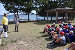
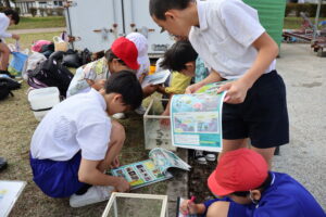
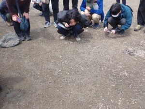
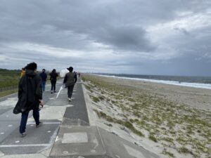
Following the recent earthquake, there were concerns about the feasibility of this year’s survey. However, on October 25, 2024, sixth-grade students from Nakajima Elementary School in Nanao City successfully completed the Survey of living creatures in satoumi. The event was organized by Nanao City, with support from specialists in the field, including Mr. Arakawa (Noto Marine Center) and Ms. Koyama ( Researcher, UNU-IAS OUIK).
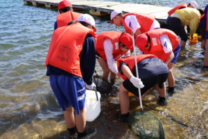
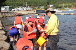
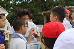
Ms. Odake from the Nanao City’s Agriculture, Forestry, and Fisheries Division began the event by welcoming everyone. Afterward, Mr. Arakawa, provided an overview of the survey methods and explained about safety precautions. The students were split into five groups, and equipped with the necessary tools, they began their survey. Using box goggles and nets, they set out in search of various creatures. Some children crawled on all fours, striving to catch crabs hiding between the stone steps, while others became so absorbed in their exploration that they waded waist-deep into the water. When the time was announced to wrap up their collecting, some students voiced their disappointment saying, “Wait, do we have to stop?”, indicating they were eager to continue their search for more creatures.
Next, it was time for species identification. The species collected were observed separately from seaweed. The students documented the organisms they found on the worksheets and newly created complemented materials by the Noto GIAHS Biodiversity Working Group. Mr. Arakawa explained about the species found and that creatures from the same family of Shitadami shells are edible. He also explained that there is a type of shellfish called Sugai (Lunella correensis), which looks similar to Shitadami but has a different shell lid shape. Crabs found by each group were gathered and placed in a single container for comparison. Two different types of crabs, Isogani (Hemigrapsus sanguineus) and Gazami (Portunus trituberculatus), were observed, revealing that the shape of the fifth leg on the Gazami crab is flattened, making it well-suited for swimming.
 |
 |
At first glance, an artificial coastal shore seemed empty, but when we took a closer look, students were able to find a variety of marine life there. Due to the effects of the earthquake, children may have fewer opportunities to go outside and connect with nature. However, OUIK hopes that this survey has helped the students appreciate the richness and charm of their local coastal environment. We also hope that they will continue deepening their understanding of how their daily lives are connected to the sea. Under the clear autumn sky, the shining smiles of the children were truly the most memorable sight of all.
2024年10月28日
2024/10/28
The International Consortium of Landscape and Ecological Engineering (ICLEE) celebrated its 20th anniversary with a conference, ICLEE2024, held from October 4 to 6, 2024, at the Kyushu Institute of Technology in Kitakyushu, Fukuoka Prefecture. This consortium includes six academic societies from Japan, Korea, and Taiwan that focus on the conservation, management, and restoration of the natural environment. Ms. Koyama (Researcher, UNU-IAS OUIK) participated in the event with the aim of learning from case studies in other regions and sharing research conducted after the Noto Peninsula earthquake.
The first day featured excursions to visit areas involved in waterfront restoration.
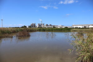
Our first stop was the Hibikinada Biotope, created on what was once a waste disposal site. This biotope, which includes wetlands and grasslands, was developed on land originally intended for industrial purposes. A protective water shield was installed to keep seawater, heavy metals, and toxins out, with the area being nourished solely by natural rainfall. Remarkably, no species were manually introduced here; instead, allowing nature to flourish has led to the discovery of over 800 species over the past three decades.
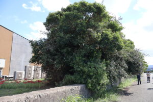
A variety of rare plants and animals inhabit this area. The presence of the bekko tonbo dragonfly (Libellula Angelina), which was first observed here in 1998 and is found in only five prefectures throughout Japan, prompted efforts to develop this site as a biotope. Additionally, several pairs of the eastern marsh harrier (Circus Spilonotus), of which only around 300 individuals exist nationwide, have settled in this biotope and are even breeding here. Furthermore, the area is home to little terns (Sterna albifrons) and harvest mouse (Micromys minutus). Along the fence surrounding the reclaimed land, plants that bear fruit favored by birds began to sprout from droppings deposited by birds 30 years ago, giving rise to a forest. Efforts have also been made in managing the wetland and constructing ponds to minimize the impact on the ecosystem.
Due to the ongoing construction of offshore wind farms and the reduction of grasslands in the surrounding area, it is expected that the landscape and ecosystem will change in the future. However, this location is likely to remain an important habitat for many living creatures.
 A spacious biotope established on reclaimed land |
 A forest flourishing along the fence of the reclaimed area |
Next, we visited the Onga River Fishway Park. The Onga River is a class A river that flows through northern Fukuoka Prefecture. In 1980, a weir (a structure that holds back river water) was constructed near the river mouth to supply water to the city of Kitakyushu. While a fishway was installed to allow fish to migrate, its design was such that fish with weaker swimming abilities were unable to ascend, and the riverbanks were covered with concrete. Therefore, around 15 years ago, a river environment improvement project was initiated. This project involved collaboration between Kyushu Institute of Technology and local residents, who worked together to develop the fishway park through workshops and other activities.
The newly designed fishway features a gentle slope that connects freshwater and seawater, allowing organisms to move freely. Stone seawalls have also been incorporated to provide passageways for wildlife, while trees like sandalwood and willow have sprouted from seeds carried by birds and wind. Artificial mudflats have been created to support crabs and shellfish. The park has been revitalized with lush greenery, including bike paths, and serves as an educational space for local children to learn about environmental stewardship.
During our visit, we witnessed a large school of mullet swimming upstream through the enhanced fishway, a testament to the ecosystem’s recovery. The Onga River Fishway Park has successfully created a rich waterside environment that draws both wildlife and visitors.
 Fishway Park, a gentle bridge between people and nature |
 A large school of mullet making their way up the fishway from the estuary |
Finally, we visited Onga River Nakajima. This area, which was once land during the Kofun period, is home to several ancient burial mounds. It became a sandbar of approximately 28 hectares due to a river excavation project around the year 1700. For a long time, it was used for agriculture, but cultivation was abandoned in 1990. In 2008, a natural restoration project began, which involved excavating the land and restoring an 8-hectare wetland environment. Thanks to this initiative, the former floodplain has been revived, and fish species that inhabit wetlands, such as the stone moroko (Pseudorasbora parva) and the silver crucian carp (Carassius langsdorfii), can now be seen again. Currently, over 1,000 species of living organisms are thriving, restoring the richness of nature. However, if left unmanaged, the area tends to become overgrown with trees, so since five years ago, efforts have been made to maintain the wetland environment, including conducting controlled burns in early spring in certain areas.
This historic sandbar area now features a cycling path that is being utilized by local residents. While there are challenges to address, such as how to continue managing invasive species and other conservation efforts, the wetlands in the Onga River basin have lost about 90% of their original area, making them a rare and valuable habitat for the creatures that inhabit these wetlands.
 Bridge to the sandbar |
 Pond created on a sandbar |
On the morning of the second day, a symposium was convened to celebrate the 20th anniversary of the organization. Representatives from various member organizations and former ICLEE leaders shared their insights on the organization’s journey thus far and discussed initiatives for the future. The importance of collaborative efforts in tackling cross-border issues was highlighted, including challenges like yellow dust, the need for integrating biodiversity conservation strategies with climate change measures, the effectiveness of implementing numerous small-scale projects rather than just a few large-scale natural restoration efforts, and the significance of ecosystem recovery in rural areas alongside urban greening that respects ecological systems.
It was also emphasized that implementing green infrastructure with a focus on disaster prevention and environmental mitigation, along with efforts that acknowledge ecosystem continuity, plays a vital role in ensuring the health of future generations and the well-being of our planet. These are critical points that should be recognized across borders with a long-term view.
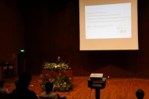
The Symposium
From the afternoon of the second day into the beginning of the third day, poster and oral presentations were held. Researcher Koyama presented a poster on a survey that examined the utilization of well water during a water supply disruption in Notojima, Nanao City. This survey was conducted in collaboration with Professor Seiji Yanai from Ishikawa Prefectural University following the Noto Peninsula earthquake. Questionnaires were distributed to all households, allowing the team to investigate and summarize the extent to which well water was utilized on the island and its significance during that time.
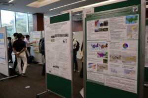
Poster Session
As we face a rise in disasters like heavy rainfall due to climate change, it has become clear that a collaborative approach is increasingly essential. Instead of tackling issues like climate change mitigation, biodiversity conservation, infrastructure development, and community and health initiatives separately, we need to foster cooperation among these areas so they can mutually enhance one another. OUIK intends to incorporate this insights into our future efforts.
2024年08月20日
On August 8 and 9, 2024, the “8th Conference of East Asia Research Association for Agricultural Heritage Systems” (ERAHS) was held in Gifu Prefecture, with approximately 250 participants from Japan, China, and South Korea. The Nagara River basin in Gifu Prefecture was registered as a Globally Important Agricultural Heritage Systems (GIAHS) as “Ayu of the Nagara River System” in 2015, and traditional fishing and regional culture continue to thrive there. During the conference, discussions were held on the theme “Connecting Agricultural Heritage to the Next Generation – Traditional Agriculture, Forestry, Fishing, and Culture,” focusing on the preservation and development of agricultural heritage.
ERAHS was established in 2013, serving as a platform for agricultural heritage stakeholders from Japan, China, and South Korea to gather annually, share knowledge, and deepen exchanges. Meetings have alternated between China, Japan, and South Korea, making this the 8th session.
At the meeting, representatives from FAO (United Nations Food and Agriculture Organization) and various governments gave keynote speeches regarding the significance and challenges of agricultural heritage. Yoshihide Endo, head of the GIAHS Secretariat at FAO, spoke about future challenges in the protection of agricultural heritage, while José María García Alvarez-Coque presented examples from Europe. Recent efforts related to agricultural heritage in China and South Korea were shared, reaffirming the importance of preserving and utilizing agricultural heritage.
Additionally, nine subcommittees were held during the conference, discussing a wide range of themes such as the next-generation inheritance of agricultural heritage, regional revitalization, protection of traditional culture, and eco-tourism. Participants shared case studies from their countries, highlighting specific efforts aimed at regional revitalization, such as brand certification in Osaki City, Miyagi Prefecture, crowdfunding on Cheongsong Island in South Korea, and legal protection for a jasmine tea brand in Fuzhou, China.
Researcher Koyama from the UNU-IAS OUIK, in collaboration with Ishikawa Prefecture, presented on “Restoration and Recovery Efforts of ‘Noto’s Satoyama and Satoumi’ GIAHS Site”. The presentation covered the damage to agriculture, forestry, fisheries, and traditional industries caused by the Noto Peninsula earthquake, as well as support systems and creative recovery efforts by the prefecture and the United Nations University.

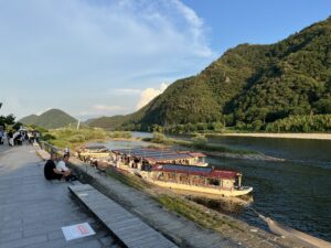
After the conference, participants had the opportunity to experience regional traditional culture and natural environments by visiting the cormorant fishing on the Nagara River and Gujo City. Activities included demonstrations of cormorant fishing, boat building tours, traditional crafts in Gujo City, and experiences at the Nagaragawa Ayu Park.


This meeting served as an important platform to reaffirm how to pass on the value of agricultural heritage to the next generation and utilize it for regional development.
2024年08月01日
At Ishikawa Prefectural Nanao High School in Nanao City, students from both the humanities and science classes have collaborated on a “Fusion Project” to explore local issues and propose solutions, aiming to envision the future of their community.
The Noto Peninsula earthquake, which struck on January 1, 2024, recorded a seismic intensity of 6+ in Nanao City, resulting in collapsed buildings, prolonged water outages, and school closures, significantly impacting the lives of local high school students. This year’s third-year students have focused on the theme of “Recovery from the Noto Earthquake,” investigating various challenges brought by the earthquake and compiling a set of 30 proposals. A presentation event was held on July 18, where Researcher Koyama from the United Nations University participated as an advisor.
The students’ proposals included a wide range of ideas, such as building a disaster-resilient community, restoring local livelihoods, and expanding community connections. Here are a few specific examples:
– Canned Noto Beef Production: Aiming to raise awareness of Noto beef, this proposal suggests developing canned products that can also serve as a disaster preparedness resource.
– Event Planning for “My Hero Academia“: An event themed around the popular anime, designed to revitalize the community and attract tourists.
– Investigation of Water Pipe Damage Using Non-Destructive Tools: Leveraging modern technology to quickly assess damage to water pipes and support early restoration.
– Event Planning for Traditional Crafts and Food Culture: Organizing events that combine local traditional crafts with food culture to promote the region’s appeal.
– Introduction of Earthquake Resistance Stickers: Implementing stickers that indicate the seismic resilience of buildings to provide reassurance to tourists.
– Mental Health Support from School Counselors: Strengthening support systems for students in need of emotional care following the earthquake, facilitated by school counselors.

Presentation by the students
The presentation encompassed diverse perspectives, with many ideas inspired by lessons learned from efforts following the Great East Japan Earthquake. Additionally, several proposals aimed to promote not only Nanao City but the entire Noto region by selling local products at events, reflecting a broader vision for regional development. These initiatives are significant as they strive for comprehensive regional growth and showcased the unique creativity of high school students, including the incorporation of anime themes and the use of social media.
The proposals announced this time included many good ideas that would be great to see realized. However, since the third-year students will now be focusing on preparing for their entrance exams, it will be difficult for them to implement the proposals themselves. Therefore, it is necessary to establish a system for handing over the projects to younger students and to create opportunities for them to continue to be involved in the community even after they become university students.
As we advance the “Recovery of Noto,” it is crucial for youth, particularly high school students, to remain actively involved in shaping Noto’s future. It is also necessary to create mechanisms for reflecting the opinions of young people in decision-making processes. We will pay attention to how the proposals of high school students will impact the region and, as the United Nations University, we plan to continuously support the youth generation.
2024年06月10日
On June 1-2, 2024, Ms. Koyama (Researcher, UNU-IAS OUIK), attended the 34th Japan Association for Landscape Ecology (JALE) Conference in Sendai to learn about issues and experiences related to regional recovery following the Great East Japan Earthquake, and to share research conducted after the Noto Peninsula earthquake.
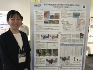
On the first day, both oral and poster presentations took place. Researcher Koyama presented a poster regarding the use of well water during the water shortage immediately following the Noto Peninsula earthquake. This study, conducted in collaboration with Special Professor Seiji Yanai (Ishikawa Prefectural University), investigated the situation of well water usage, its quality, and its relationship with geology in Nanao City, Notojima. By visualizing the data using GIS, the research underscored the importance of securing water sources in the region in preparation for future disasters.
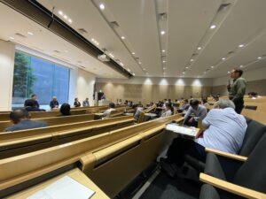
The afternoon seminar featured presentations on long-term monitoring efforts of sandy beach ecosystems in coastal areas post-Great East Japan Earthquake, the process of pine forest regeneration, and community-driven initiatives aimed at recovering coastal vegetation. Attendees learned about the significance of researchers’ involvement in the recovery process and the value of citizen participation in these efforts.
|
Poster Presentation
|
Panel Discussion
|
Participants took part in an excursion the following day to the Sanriku coast area, where they visited sites affected by the tsunami from the 2011 Great East Japan Earthquake and facilities where recovery projects are underway. The Kamoi tidal flat, located at the mouth of the Nanakita River, is rich in benthic organisms such as shellfish and crabs, and has been known as a stopover site for migratory birds. However, the environment was significantly devastated by the tsunami from the 2011 earthquake. To protect this tidal flat, local residents and researchers collaborated to advocate to the government to reconsider the location of the seawall construction, relocating it inland, which helped preserve the wetland. (The canal running along the coastal sandy beach was constructed from the Edo period to the Meiji period.)
 The coastal wetlands and tidal flats that have been preserved by relocating the flood control levee. |
 Participants peering into the abundant shellfish found in the tidal flats. |
 A surviving black pine forest that was spared from tsunami damage (with tall trees) alongside a dense regeneration of young black pines underneath. |
 A walking path (art installation) established along the coastal area that was affected by the tsunami. 津波で被災した沿岸部に設置された
遊歩道(アート作品)
|
 A flood control levee where sand has accumulated and coastal plants have begun to take |
 Hamabōfu (Coastal Plant)
|
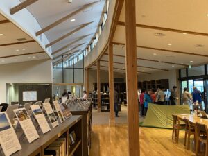
Afterward, the participants visited the MCT Natori Trail Center, one of the facilities of the Michinoku Coastal Trail, which connects the Pacific coast from Aomori Prefecture to Fukushima Prefecture. This 1,000-kilometer trail (sidewalk) was created after the Great East Japan Earthquake through the collaboration of the Ministry of the Environment, relevant local governments, private organizations, and local residents. It was established as a path that conveys beautiful natural scenery, memories of the earthquake, and the lives, history, and culture of people living in harmony with nature, fostering interaction between local residents and visitors. Currently, it connects 4 prefectures and 29 cities and towns. Local elementary schools are involved in route planning and map creation, and community-rooted initiatives are being promoted. In recent years, it has also gained attention as a tourist destination, being selected by National Geographic as one of the “World’s Must-See Destinations of 2020.”
 Inside the Natori Trail Center |
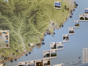 Trail map |
In this conference, participants were provided with opportunities to learn about various cases related to the recovery process 13 years after the earthquake, the protection of valuable natural environments, and the involvement of researchers in utilizing these areas as regional resources through field inspections. It was confirmed that there are places where sand has accumulated due to the construction methods of coastal levees, leading to the recovery of vegetation, as well as areas where pine growth is delayed and the increase of invasive and inland species has posed challenges in pine forest restoration sites where soil transported from inland areas has been used for embankment. Moreover, the importance of long-term monitoring of changes in the coastal areas post-disaster and sharing the results was also recognized. These insights are expected to be utilized in future research activities by OUIK aimed at recovery in Noto.
2024年07月16日
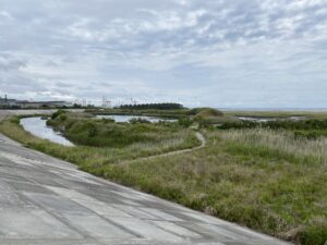
On June 5, 2024, a group of experts from the Noto GIAHS Biodiversity Working Group conducted a field inspection of the Machino River basin in Wajima city, which experienced significant damage from the Noto Peninsula earthquake and notable changes to the coastal environment due to land uplift.
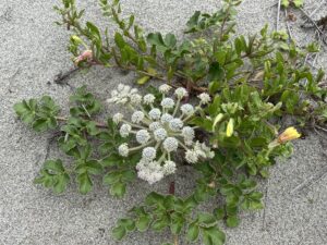
At the Machino river mouth, rocks that were previously submerged in seawater were fully exposed, and numerous dead intertidal species, including purple barnacles, razor clams, and barnacles, could be seen. This illustrated the profound impact the earthquake had not only on humans but also on the marine life along the coast. River embankments were severely damaged, and channels that once flowed with water had completely dried up. However, while there were negative impacts on the wildlife, the earthquake also created new habitats. Due to land uplift, sandy beaches extended nearly 80 meters towards the sea, causing the previously straightened river mouth to meander along the newly formed sand. This area attracted many seabirds, including black-tailed gulls, which gathered to bathe and rest. Coastal vegetation was also beginning to take root in the expanded sandy areas.
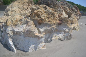
Exposed rocks due to uplift
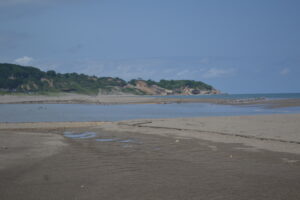
Seabirds congregating along the widened sandy beach and meandering river
In the eastern region, designated as a model area for the release of the Crested Ibis, the situation was challenging post-earthquake, yet rice paddies with water and planted rice were still present. However, some fields had become uneven, causing water to accumulate on one side, and there were instances where damaged irrigation channels prevented water from being diverted to certain paddies, reflecting the earthquake’s impact. Farmers expressed concern that some residents had left the area due to the earthquake, leading to labor shortages for tasks such as grass cutting which had previously been shared by the community.

Rice paddies designated as a model area for the Crested Ibis release in Ishikawa Prefecture
We also visited the wetland area in the middle reaches of the river, which had expanded due to stagnant water caused by the earthquake. As we approached the wetlands, we could hear various birds chirping. Observing the surroundings revealed many creatures, including snakes, crabs, dragonflies, and shellfish. Despite the major impacts of the earthquake, it was evident that diverse species were adapting to the new environment.
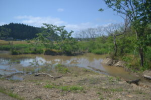
Wetlands expanded after the earthquake
While the earthquake caused extensive damage, it is also crucial to consider how to leverage the new environments created by the disaster as resources for the community. This will play an essential role in creating an attractive region and achieving recovery in the future. During this inspection, we received cooperation from local residents who expressed their desire to “consider community recovery by utilizing the natural environment of the satoyama and satoumi.” The Working Group aims to collaborate with experts from both within and outside the region to support local residents and municipalities in restoring the rich lifestyle of Noto’s Satoyama and Satoumi, as well as the natural environment that sustains it.
2024年03月28日
The Noto Peninsula earthquake that occurred on January 1, 2024, caused extensive damage over a wide area, isolating many communities due to landslides that disrupted roads. Additionally, essential lifelines such as water and electricity were interrupted in numerous regions. Particularly in municipalities in the Oku-Noto area and Nanao City, prolonged water supply disruptions have been experienced, with many areas still without water nearly three months after the earthquake.
Amidst this ongoing situation, research associate Koyama has begun an investigation into the use of water sources within the community, including wells and springs.
Through interviews with local residents and on-site surveys, there are plans to explore ways to utilize water for building a resilient community in the face of disasters.
2023年10月30日
The Agricultural Heritage Symposium is scheduled to take place in Nanao City, Ishikawa Prefecture, on November 10, 2023. As a part of this event, Ishikawa Prefecture and UNU-IAS OUIK will co-host a “Youth Session” aimed at fostering an exchange of ideas among high school students from agricultural heritage areas.
On October 19, 21 high school students from 11 schools across 7 Globally Important Agricultural Heritage Systems (GIAHS) sites and 1 Japanese Nationally Important Agricultural Heritage Systems site gathered online for a preliminary study session in preparation for the Youth Session. They engaged in discussions around questions such as “What is Important Agricultural Heritage Systems?”, “How did the youth session come about?”, and “What will we do on the day of the event?” The session began with an introduction to the research conducted by UNU-IAS OUIK.
The first speaker, Mr. Akira Nagata, a Research Fellow at UNU-IAS OUIK, delivered a lecture titled “What is Important Agricultural Heritage Systems?”. The presentation covered topics such as the Globally Important Agricultural Heritage Systems (GIAHS) recognition program, GIAHS sites both within Japan and internationally, and what kind of ripple effects (positive impacts) result from receiving GIAHS designation.
Following this, OUIK researcher Ms. Koyama provided an overview of the GIAHS Youth Summit held in FY2021 and its outcomes. She also introduced the “Opinion Exchange Meeting among High School Students from Important Agricultural Heritage Systems Designated Areas,” which took place last fiscal year.
In the second half of the session, participants were divided into groups to introduce themselves and share their impressions and opinions based on the earlier presentations. They then presented their insights to one another. Some participants expressed surprise at the abundance of GIAHS in Asia, while others were grateful for the opportunity to engage in discussions with fellow students and appreciated the chance to share their views with adults.
Finally, Mr. Fukuda and Ms. Koyama wrapped up the session by outlining the day’s agenda and related preparations. Several participants expressed their enthusiasm for visiting Ishikawa Prefecture in November, and the overall meeting served as a valuable preparation for the upcoming in-person Youth Session event.